Contemporary age (20th century)
Military heritate
The 20th century began with the partial demolition of the walls of Cádiz, a process that was increasing and that radically transformed the urban fabric of the city.
Maritime heritage
The construction of the Cádiz-San Fernando tramway contributed to the appearance of recreational places and the Balneario de la Victoria and summer villas.
Industrial heritage
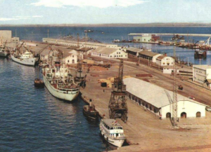
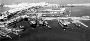
The 20th century experienced a boom in shipyards, especially the Navantia company, and the Puntales electrical tower was created .

The fall of the walls
The 20th century began for the city of Cádiz with the authorization of the permit for the partial demolition of the wall, a historical event that took place in 1903 and that gave rise to a new urban transformation towards the current appearance of the city. The demolition material generated from its destruction was reused for the urbanization outside the walls and the filling of the dock, Canalejas and Plaza España.
It should be remembered that at the end of the 19th century, colonization outside the walls was limited to the suburb of San José, the nucleus of San Severiano and the neighborhood of Puntales, related to seafaring and shipbuilding activities. The rest of the territory was restricted to small constructions related to fishing, warehouses and factories located in a disorderly manner that formed a network of roads where spaces for orchards were located.
Starting in the second half of the 19th century, the walls gradually lost their importance and significance, becoming an urban promenade with a great landscape character. The desire to overcome the past together with the desire for modernization, the need to connect with the new port and the urbanization of the area outside the walls motivated the idea of demolishing the walls, which was carried out without any overall plan except for adaptation to the urban concepts of industrialization, expansions and interior reforms of the city.
In the 1980s, the first proposals for demolition emerged based on the urbanization of the area outside the walls, alleging hygienic, social and aesthetic needs.
In 1893, the demolition permit was requested for the walls of the sector that goes from the Customs House to the Land Gates, although it was denied; This fact led to the subsequent search for new approaches regarding its justification.
The decisive period for the long-awaited demolition of the walls of Cadiz took place between 1904 and 1906 with the mandate of the mayors González de Aramburu, Cayetano del Toro and Segismundo Moret. On February 13, 1906, the collapse of the sector between the bastion of San Antonio and that of Los Negros was authorized and, later, on February 26, the urbanization of the area outside the walls was also authorized.
On March 3, 1906, the demolition began from Puerta del Mar. From this point the works continued on both sides to the front of Puerta de Tierra and Puerto Piojo.
Said landslide was carried out in two phases: the first dealt with the section that goes between the current Diputación and the bastion of the blacks; while in the second, the walls that surrounded the current Plaza de España were intervened to erect the monument to the Cortes on its esplanade.
In the years from 1907 to the end of the 1920s, the request for new demolitions and the problem of reusing the materials from the demolition took place, for which the Walls Commission was created, which sought to provide solutions to the problems generated by the improvisation of the works. In this phase, the controversy arose about the ownership of the liberated land and, given the lack of understanding between the Ministry of War and the City Council, Ramón de Carranza, mayor of the city, planned the urbanization of Paseo de Canalejas and Plaza of Spain in the years of 1928 and 1929.
With the urbanization of Canalejas, the city found the perfect substitute for those walks along the royal wall that also included the installation of terraces in the bars in the area and that were very well received by the citizens.
Between 1930 and 1947 and after the granting of military barracks and glacis to the city, the sector outside the walls between Puerta de Tierra and Avenida de Portugal was gradually consolidated. The surroundings of the San José neighborhood were urbanized in the streets of Sociedad, Campos Elíseos, Amigos del Árbol, the area of the former bullring, and the Paseo Marítimo was built on the Victoria beach, the Plaza de la Constitución to which the steelwork of Ana de Viya, Cayetano del Toro and Trille was added.
The year 1947 was marked by another great historical event that caused great damage to the city. On August 18 of that year, the ammunition stored in the Navy Submarine Defense Base exploded, totally destroying the industrial facilities and residential areas around San Severiano. The phenomenon of the explosion had an immediate effect on the return of the population to the old town with a large agglomeration of inhabitants in the popular neighborhoods.
In the area outside the walls, the closest to the scene of the incident, most of the existing buildings were seriously damaged; In intramuros, houses and buildings suffered structural damage, although with a much lower degree of damage. A large number of people were left without homes, so they were installed in temporary camps that were replaced by groups of wooden barracks that were left in different neighborhoods of the city.
In addition to the damage to homes, the catastrophe also caused extensive damage to public buildings such as the Gran Teatro Falla, the Cathedral Church, the Balneario de la Palma, which was being renovated at the time, the Reformatorio de Menores located in Callejón Trille and the Hogar del Niño de Jesús or Casa Cuna, completely destroyed.
The main industries of the city were also destroyed, such as “Gas Lebón” and the “Astilleros de Echevarrieta y Larrinaga”, the military installations of the Navy belonging to the San Severiano neighborhood, in the case of the Hydrographic Institute of the Navy, and the military barracks of the infantry close to the neighborhood of San José.
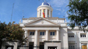
Around the year 1943, faced with the need to strengthen hydrography, the hydrographic service became independent from the Marine Observatory, thus creating the Navy Hydrographic Institute. Said body, dependent on the General Staff of the Navy, arose with the aim of giving impetus to cartography and achieving greater action in the functions related to hydrography and navigation. Its cartographic production is granted the category of State Cartography and Official Documentation and mandatory use for the navigator.
The Institute, which was located in Cádiz from the moment of its creation, was totally destroyed by the effects of the explosion, having to undertake a reconstruction of its facilities that was completed in 1955.
On the other hand, the infrastructure of the city was severely damaged as all basic supplies and communications were interrupted. The railway tracks disappeared in the section near the Underwater Defense Base, the power line poles were blown up causing a general blackout as well as the telephone lines, the water supply network burst and left without supply to the entire the population.
After this event, urban restructuring was proposed through the urban planning plan, the rebuilding of the affected area and the injection of public funds by the City Council, Provincial Council and Civil Government. The District Office of Devastated Regions focused on the reconstruction of the San Severiano neighbourhood, the low houses of the Barriada España and the first blocks of Cerro del Moro.
Evolution of the city of Cádiz through its military, maritime and industrial heritage (MMI)