Modern age (16-17th century)
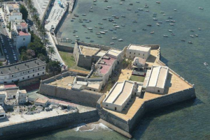
Military heritage
The fortification of Cádiz began with Carlos V, who promoted fronts with bastions, and it was improved and expanded throughout the 16th and 17th centuries along its entire perimeter.
Maritime heritage
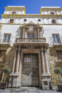
Thanks to the security provided by the city’s defense system and the boom in trade, a series of families of porters from the Indies settled and the “merchant’s house” was developed.
Industrial heritage
In the 16th and 17th centuries Cádiz had two tuna traps: San Felipe and Torregorda or Torre de Hércules. The fishing corrals, the tide mills and the salt pans also had an important development.

A budding growth
In the view of Cadiz of 1513, we contemplate a panorama of the first urban framework of the city. With a view projected from the back of Cadiz’s bay is possible to observe the current neighborhood of the Pópulo.
The city wall provides with a free and singular vision stressing the defensive character of his buildings while the Church of Santa Cruz, or popularly known as the ” old cathedral”, stands out.
From beginning of the 16th century there are evidences about two suburbs in the outside areas of the city wall around Santa Maria’s church and Misericordia’s hermitage, constituting the starting point Cadiz urbanism in the Modern Age and from which there were projected constructions of habitat that when they fused, they provided a very recognizable aspect to the city
During the 16th century and especially until middle of the 17th century the most urbanized areas were the ones associated to the current San Juan de Dios square and surroundings, Santa Maria’s neighborhood, la Candelaria’s square and the line parallel to the maritime port, up to reaching a limit close to Sagasta street, which it was used in the beginning as urban limit of the modern Cadiz.
Cadiz’s engraved by Anton Van der Wyngaerde. 1567 From the second half of the 17th century there was stablished a demographic expansion that involved an urban growth towards the south front, Jara’s field zone – currently San Antonio’s square – and specially to La Viña’s neighborhood. The urbanization constructions began in 1687 replacing progressively the areas of agricultural produc,on and the deriva,ves of a basic industry with a residen,al zone for people of modest economy. There was built a chapel (1693) that was the origin of the current Church of la Palma. Of this form, the city remained defined at the end of the 17th century by two differentiated zones. One, of popular and poorer character, placed in the parts south and southwest, and another one, identifiable with the rich zone of the city, dwelt of merchants and with subjects in good economic situation, in the north part and northwest , articulated around la Jara, San Francisco and the near areas to the port.
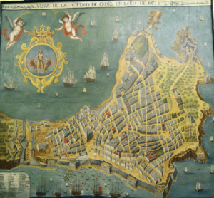
The physiognomy of Cadiz urbanism relates both to the ultramarine trade and to his geostrategic importance. It was a point very coveted by the enemy powers of the Hispanic monarchy that they were fighting for taking part in the sharing out of the American wealths, that fact was verified after the Anglo-Dutch assault in 1596.
The Cadiz port turns into the door of entry and exit from Europe towards the new continent and it needed a special attention the part of the Crown to protect the colonial trade. Cadiz has in his urban space the military – defensives needs of the epoch and grew up sheltered by the ideas of engineers and military architects who developed a structural framework formed by linen of ramparts, bastions and small castles that shaped a sure set for their inhabitants and for the commercial activity.
Evolution of the city of Cádiz through its military, maritime and industrial heritage (MMI)